Map scales zooms
Web maps have 20 preset scales, learn these “zoom” levels and their natural scale equivelents.
- Where Am I - Python code for converting between lat/long and TMS coords.
- Getlatlon - Search for a place, discover it's coordinates.
- Aaron's version of GetLatLong - Decimal degrees, DDMMSS, geohash, and WOE ID place reverse geocode.
- MapTiler - See the TMS coords labeled on a live Google map.
- Scale Master - Interactive tool (Flash) and papers from Cindy Brewer at Penn state on what to include on your map, when.
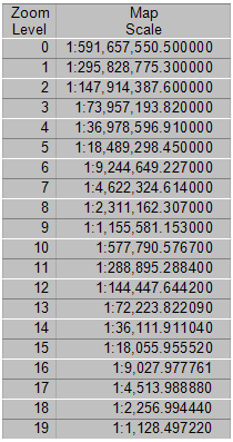
- Esri Mapping Center table (txt src):
Formula for converting pixels in Web Mercator to meters per zoom:
20037508*2 / 2^(8 + zoom)
Example:
19.1 meters = 20037508 * 2 / 2^(8 + 13)
Code:
def zoom_threshold(zoom):
    return meter_to_mapunit(20037508.0 * 2 / (2**(9 + zoom)))
1:2,000,000 to about 1:250,000 are SMALL-scale maps. Items on these maps appear small (e.g. a county on a 1:2,000,000 map is much smaller than on a 1:100,000 map).
1:24,000 on towards 1:9,600 are LARGE-scale maps. Items on these maps appear larger. 1:100,000 are pretty much in the middle – intermediate scale.
Oregon State University Library http://oregonstate.edu/~reeset/html/scale.html
Type in the number of units per distance (or distance per unit) and it’ll return the relational fraction. It does not do a very good job allowing you to type in both the units and the distance as variable. I hardly ever find scale bars on maps that are exactly an inch long. So involves some pre-math to get this tool to work.
This University of Texas site does the opposite: http://www.beg.utexas.edu/GIS/tools/scale2.htm
Enter the representational fraction of the map and get “1 inch = X miles” verbal statements where the left and right terms do not have the same units.
Some example map scales and worked formula examples from Richard Layton (source).
1 inch equals 10 miles 1 inch = 10 miles 1 inch = 10 miles x 12 inches/foot x 5280 feet/mile 1 inch = 10 x 63360 inches = 633,600 inches 1:633,600 To convert from RF to Verbal Scale you convert the fraction to familiar units of measurements; for example:
1:250,000 1 inch = 250,000 inches 1 inch = 250,000 inches [d] 12 inches/foot = 20,833.3 feet 1 inch = 20,833.3 feet [d] 5280 feet/mile = 4 miles or 1 inch = 250,000 [d] 63360 inches/mile = 4 miles 1 inch equals 4 miles [Note: [d] = divided by]
SOME COMMON SCALES. Here is a list of RF scales commonly used in the Map Collection and their equivalent Verbal Scales.
1:24,000 - 1 in. = .379 mi. 1:62,500 - 1 in. = .986 mi. 1:100,000 – 1 in. = 1.578 mi. 1:250,000 - 1 in. = 4 mi. 1:500,000 - 1 in. = 7.891 mi. 1:1,000,000 – 1 in. = 15.783 mi. For example you want a map of Arizona on a 8 1/2 x 11 inch piece of paper. To allow for 1/2-inch margins the new sheet will then be 7 1/2 x 10 inches. Since Arizona’s north-south dimension, 395 miles, is slightly longer than its east-west dimension, 340 miles, we will place the longer north-south dimension along the longer 10-inch dimension of the paper. The next step is to compute the scales for both dimensions of the State. The smaller of the two scales will be the one we need.
North-south 10 in = 395 mi 10 in = 395 mi x 63360 in/mi 10 in [d] 10 = 25027200 in [d] 10 1 in = 2502720 in 1:2,502,720
East-west 7.5 in = 340 mi 7.5 in = 340 mi x 63360 in/mi 7.5 in [d] 7.5 = 21542400 in [d] 7.5 1 in = 2872320 in 1:2,872,320
[Note: [d] = divided by]
We therefore need a map of Arizona at a scale of 1:2,872,320 or less to place it on an 8 1/2 x 11 inch sheet of paper.
Scale
Miles/inch
Line Width on Ground*
Examples
1:2,000,000
~32
2000’
USGS Nation-wide maps
1:1,000,000
~16
1000’
National and state maps
1:500,000
~8
500’
State or regional maps
1:250,000
~4
250’
US Army Map Series
1:100,000
~1.6
100’
USGS 30′ quads
1:62,500
5208 feet
62.5’
USGS 15′ quads
1:24,000
2000 feet
24’
USGS 7′ quads
1:15,840
1320 feet
15.84’
Soils
1:9,600
800 feet
Aerial photos
*Approximate real width on ground of a pencil line on a map – harder pencils give a finer line
#Map Projections
- EPSG Projection Extent Polygons - For coordinate reference systems and for coordinate transformations in the EPSG Dataset, the geographic extent of the area of applicability is described. In a mapping application, using the polygons will greatly reduce the risk of inappropriate CRS selection. It will also minimise the risk of applying the geodetic data to inappropriate areas.
- USA State Planes
- California counties